
Current Planning Process
Overview
The Diridon Station Program is a collection of proposed projects organized into two groups: Station Elements and Southern Roadway Projects.
Program Purpose
The purpose of the Diridon Station Program is to create a Diridon Station that will:
Be well-equipped for future growth and ridership
Connect different transit systems
Integrate with planned land use in the downtown area
Current Program Phase
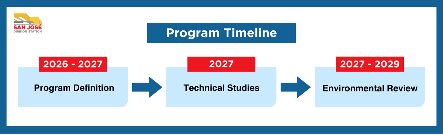
We are in the Environmental Phase. The current focus is on Program Definition. Upcoming are Technical Studies and National Environmental Policy Act (NEPA) documentation. Current Program planning focuses on the three main milestones described below.
| Milestone | Description |
|---|---|
| Program Definition (2026/2027) | The technical team is defining the program elements in enough detail to support the next phase of technical study and the environmental review. |
| Technical Studies (2027) | The team will prepare Technical Studies to evaluate how proposed changes to the Diridon Station area may affect topics such as air quality, cultural resources, and noise, among other topics. |
| Environmental Review (2027 – 2029) | The Environmental Review will disclose potential effects associated with the proposed changes to the Diridon Station area and potential ways to reduce those effects. The draft Environmental Review will be shared for public input and finalized for decision-makers to use. |
Decisions from the Business Case
The Business Case was a two-year effort (2023 – 2025). It used technical work and community engagement to check the potential costs, benefits, risks, and tradeoffs of the Program.
The Business Case advanced an “at-grade” station design alternative. This keeps the station’s tracks and platforms at their current level and adds a new central concourse below. Other alternatives, including “elevated” and “stacked” designs, were not advanced because of cost, disruption of current operations, and community impacts. For more information on the Business Case alternatives, check out the 2025 Diridon Station Online Open House.
Business Case community engagement included over 40 community events with more than 5,700 comments received. Input helped shape decisions to prioritize walkability, biking, transit access, preservation of the historic station building, and minimizing construction impacts on surrounding neighborhoods.
Besides advancing the at-grade station design alternative, the Business Case established the Program of Projects in June 2026. This created the foundation for the current planning process. Public input will continue to guide how the Program is defined, studied, and reviewed. It will also impact future decisions during Technical Studies and Environmental Review.
What Projects Make Up the Program
Station Elements
The Program will add or change parts of the station, including:
Tracks, Platforms, and Concourse
Historic Depot
Plaza
VTA Light Rail Station
Transit Facilities
Several Roadway Crossings
Transit-Oriented Developments
Southern Roadway Projects
The Program also includes Southern Roadway Projects which would modify street crossings where Park Avenue, San Carlos Street, Auzerais Avenue, and West Virginia Street meet the train tracks.
Program of Projects: Diridon Station Project Elements & Southern Roadway Projects
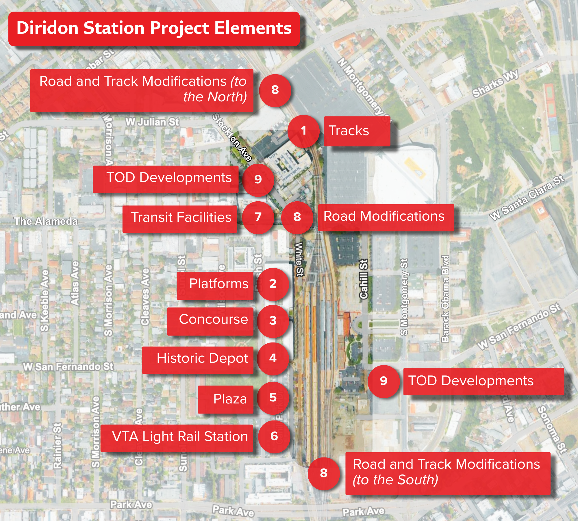
Map of Diridon Station Project Elements.
Station Elements
| Number | Name | Description |
|---|---|---|
| 1 | Tracks | The main station tracks will stay roughly at the same ground elevation they are at today. The surrounding neighborhood streets will be modified so that people can travel over or under the tracks – this effort is part of the Southern Roadways Projects in the Program. |
| 2 | Platforms | Platforms provide direct access to the trains services including Caltrain, Altamont Corridor Express (ACE Rail), California High-Speed Rail, Capitol Corridor, Amtrak, Gold Runner, and the future underground BART and Santa Clara Valley Transportation Authority (VTA) light rail. |
| 3 | Concourse | A new, large concourse will be constructed for the station and placed below the tracks and platforms. This will become the primary transit rider concourse and include the main station entrances, ticketing, and other customer amenities. |
| 4 | Historic Depot | The historic depot is listed in the National Register of Historic Places and is designated as a San José City Landmark. The depot will be preserved and reused. The Program Team is working closely with the State Historic Preservation Office (SHPO) and the local Historic Working Group. |
| 5 | Plaza | There will be a plaza on the east and west sides of the station. The new plaza will slope down to the station and feature public amenities that are yet to be determined. |
| 6 | VTA Light Rail Station | The current VTA light rail station and its tracks and platforms will be rebuilt and moved underground. |
| 7 | Transit Facilities | Local and regional bus operations will be moved away from the main station area. Regional buses will have a new dedicated facility at the northeast corner of Stockton Avenue and W. Santa Clara Steet. Local buses will run and have stops along Santa Clara Street. |
| 8 | Road Modifications | Road crossings near the station will be improved to make them safer and easier to use including W. Taylor Street, W. Julian Street, and W. Santa Clara Street. Several other roads near the station will also be modified including N. Montgomery Street, Stockton Avenue, and the Alameda. |
| 9 | Transit-Oriented Developments | All the Station Projects will be designed to work with the existing businesses, offices, housing, and parks. In addition, the Program is considering new TOD south of the historic depot and at the location of the new transit center at the northwest corner of Stockton Avenue and W. Santa Clara Street. |
Southern Roadway Crossings Projects
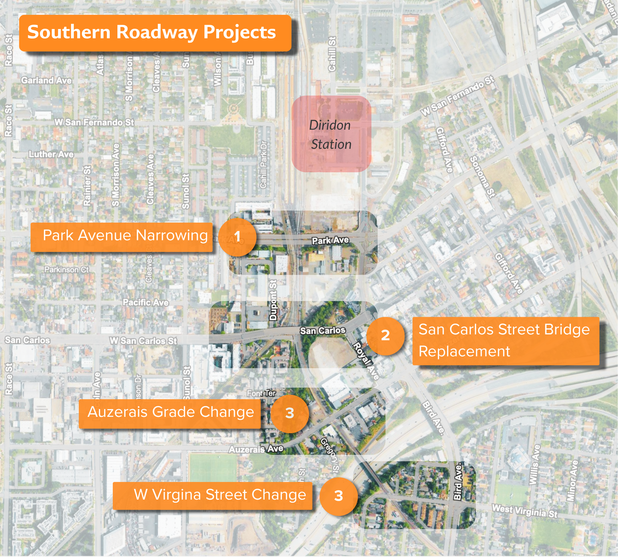
Map of Southern Roadway Projects.
| Number | Name | Description |
|---|---|---|
| 1 | Park Avenue | The existing street will be narrowed to allow for more adjacent land to be developed. |
| 2 | San Carlos Street | The existing roadway bridge will be replaced as the existing bridge is substandard. |
| 3 | Auzerais Avenue | The street for vehicles will be lowered to be beneath the existing tracks, and pedestrian and bicycle facilities will be added to the crossing. |
| 4 | West Virginia Street | The street will be closed to vehicles and a new pedestrian and bike undercrossing will be added. |